Property Record
3601 N Highway 27, Carrollton, GA 30117
NEARBY LISTINGS FOR SALE OR LEASE
-
-
View all Carrollton listings for sale on LoopNet.com
Property Detail
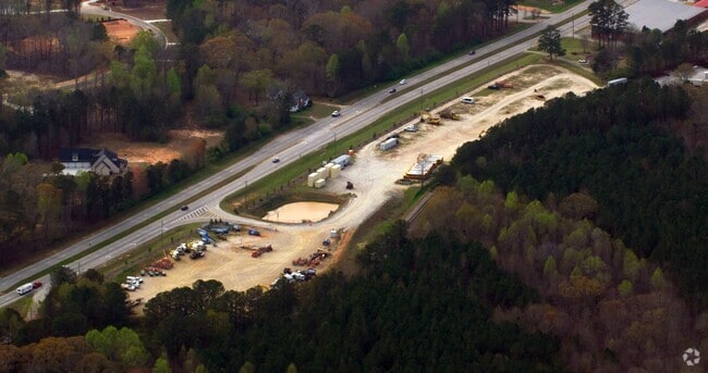
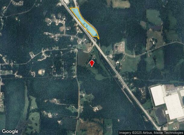
3601 N Highway 27
072-0032
TR-1B (8.01AC) HWY 27 N
Commercialnec
Carroll
X
Georgia
13143C0250B
8.01 AC
2025
W Carroll County
2025
Atlanta
910301
Atlanta-Sandy Springs-Roswell, GA
DEMOGRAPHICS near 3601 N Highway 27
1 Mile
3 Mile
5 Mile
2024 Total Population
763
5,459
22,247
2029 Population
859
6,154
24,878
Pop Growth 2024-2029
+ 12.58%
+ 12.73%
+ 11.83%
Average Age
37
38
37
2024 Total Households
281
1,929
7,887
HH Growth 2024-2029
+ 12.81%
+ 12.80%
+ 11.91%
Median Household Inc
$39,582
$49,923
$51,629
Avg Household Size
2.70
2.80
2.70
2024 Avg HH Vehicles
2.00
2.00
2.00
Median Home Value
$248,275
$207,237
$184,587
Median Year Built
1985
1990
1990
Nearby Places
Map Layers
Map Styles
 Street
 Aerial
- Restaurants
- Banks
- Shops
- Fitness
- Groceries
Nearby Properties
Address
Land Use
TOTAL SIZE
Lot Size
Zoning
Address
Land Use
TOTAL SIZE
Lot Size
Zoning
932,068 SF
150.44 AC
I
Address
Land Use
TOTAL SIZE
Lot Size
Zoning
452,050 SF
34 AC
M2
Address
Land Use
TOTAL SIZE
Lot Size
Zoning
820,922 SF
84.15 AC
M2
Address
Land Use
TOTAL SIZE
Lot Size
Zoning
162,219 SF
31 AC
M2
Address
Land Use
TOTAL SIZE
Lot Size
Zoning
170,850 SF
10.97 AC
M2
Address
Land Use
TOTAL SIZE
Lot Size
Zoning
341,714 SF
44.49 AC
M2
Address
Land Use
TOTAL SIZE
Lot Size
Zoning
101,000 SF
15 AC
RESIDENTIA
Address
Land Use
TOTAL SIZE
Lot Size
Zoning
128,000 SF
0.74 AC
M2
Address
Land Use
TOTAL SIZE
Lot Size
Zoning
117,105 SF
8.74 AC
M2
Address
Land Use
TOTAL SIZE
Lot Size
Zoning
109,300 SF
127 AC
I
Address
Land Use
TOTAL SIZE
Lot Size
Zoning
39,500 SF
15.36 AC
OI
Address
Land Use
TOTAL SIZE
Lot Size
Zoning
64,000 SF
0.24 AC
M2
Address
Land Use
TOTAL SIZE
Lot Size
Zoning
75,840 SF
6.90 AC
M2
Address
Land Use
TOTAL SIZE
Lot Size
Zoning
101.95 AC
RESIDENTIA
Address
Land Use
TOTAL SIZE
Lot Size
Zoning
138,320 SF
16.67 AC
M2
Address
Land Use
TOTAL SIZE
Lot Size
Zoning
40,000 SF
Address
Land Use
TOTAL SIZE
Lot Size
Zoning
29,600 SF
11.24 AC
001
Address
Land Use
TOTAL SIZE
Lot Size
Zoning
31,965 SF
5.47 AC
M1
Address
Land Use
TOTAL SIZE
Lot Size
Zoning
51,408 SF
4.69 AC
C
Address
Land Use
TOTAL SIZE
Lot Size
Zoning
26,348 SF
5.50 AC
C
Address
Land Use
TOTAL SIZE
Lot Size
Zoning
47,320 SF
17.84 AC
C
Address
Land Use
TOTAL SIZE
Lot Size
Zoning
57,450 SF
15.60 AC
M2
Address
Land Use
TOTAL SIZE
Lot Size
Zoning
7,072 SF
36.89 AC
COMM
Address
Land Use
TOTAL SIZE
Lot Size
Zoning
105,034 SF
9.05 AC
M2
Address
Land Use
TOTAL SIZE
Lot Size
Zoning
15,000 SF
18.55 AC
C
Address
Land Use
TOTAL SIZE
Lot Size
Zoning
29,750 SF
5.23 AC
M2
Address
Land Use
TOTAL SIZE
Lot Size
Zoning
9,230 SF
19.08 AC
A
Address
Land Use
TOTAL SIZE
Lot Size
Zoning
286.25 AC
AG
Address
Land Use
TOTAL SIZE
Lot Size
Zoning
9,292 SF
31.71 AC
004
Address
Land Use
TOTAL SIZE
Lot Size
Zoning
40,000 SF
5.94 AC
M2
The World's #1 Commercial Real Estate Marketplace
Connect with us
© 2025 CoStar Group
The information above has been obtained from sources believed reliable. While we do not doubt its accuracy we have not verified it and make no guarantee, warranty or representation about it. It is your responsibility to independently confirm its accuracy and completeness. Any projections, opinions, assumptions, or estimates used are for example only and do not represent the current or future performance of the property. The value of this transaction to you depends on tax and other factors which should be evaluated by your tax, financial, and legal advisors. You and your advisors should conduct a careful, independent investigation of the property to determine to your satisfaction the suitability of the property for your needs.